Global Warming

Global Warming

Global Warming

Global Warming

Global Warming

Global Warming

Global Warming

Global Warming

Global Warming

Global Warming

Thursday, 2 February 2012

NASA Spacecraft Returns First Video from Far Side Of The Moon

WASHINGTON -- A camera aboard one of NASA's twin Gravity Recovery And Interior Laboratory (GRAIL) lunar spacecraft has returned its first unique view of the far side of the moon. MoonKAM, or Moon Knowledge Acquired by Middle school students, will be used by students nationwide to select lunar images for study.

GRAIL consists of two identical spacecraft, recently named Ebb and Flow, each of which is equipped with a MoonKAM. The images were taken as part of a test of Ebb's MoonKAM on Jan. 19. The GRAIL project plans to test the MoonKAM aboard Flow at a later date.

To view the 30-second video clip, visit:

http://go.nasa.gov/zZXAPs


In the video, the north pole of the moon is visible at the top of the screen as the spacecraft flies toward the lunar south pole. One of the first prominent geological features seen on the lower third of the moon is the Mare Orientale, a 560 mile-wide (900 kilometer) impact basin that straddles both the moon's near and far side.

The clip ends with rugged terrain just short of the lunar south pole. To the left of center, near the bottom of the screen, is the 93 mile-wide (149 kilometer) Drygalski crater with a distinctive star-shaped formation in the middle. The formation is a central peak, created many billions of years ago by a comet or asteroid impact.

"The quality of the video is excellent and should energize our MoonKAM students as they prepare to explore the moon," said Maria Zuber, GRAIL principal investigator from the Massachusetts Institute of Technology in Cambridge.

The twin spacecraft successfully achieved lunar orbit last New Year's Eve and New Year's Day. Previously named GRAIL-A and -B, the washing machine-sized spacecraft received their new names from fourth graders at the Emily Dickinson Elementary School in Bozeman, Mont., following a nationwide student-naming contest.

Thousands of fourth- to eighth-grade students will select target areas on the lunar surface and send requests to the GRAIL MoonKAM Mission Operations Center in San Diego. Photos of the target areas will be sent back by the satellites for students to study. The MoonKAM program is led by Sally Ride, America's first woman in space. Her team at Sally Ride Science and undergraduate students at the University of California in San Diego will engage middle schools across the country in the GRAIL mission and lunar exploration. GRAIL is NASA's first planetary mission carrying instruments fully dedicated to education and public outreach.

"We have had great response from schools around the country, more than 2,500 signed up to participate so far," Ride said. "In mid-March, the first pictures of the moon will be taken by students using MoonKAM. I expect this will excite many students about possible careers in science and engineering."

Launched in September 2011, Ebb and Flow periodically perform trajectory correction maneuvers that, over time, will lower their orbits to near-circular ones with an altitude of about 34 miles (55 kilometers). During their science mission, the duo will answer longstanding questions about the moon and give scientists a better understanding of how Earth and other rocky planets in the solar system formed.

NASA's Jet Propulsion Laboratory in Pasadena, Calif., manages the GRAIL mission for NASA's Science Mission Directorate in Washington. The GRAIL mission is part of the Discovery Program managed at NASA's Marshall Space Flight Center in Huntsville, Ala. Lockheed Martin Space Systems in Denver built the spacecraft.

NASA finds 2011 ninth-warmest year on record

While average global temperature will still fluctuate from year to year, scientists focus on the decadal trend. Nine of the 10 warmest years since 1880 have occurred since the year 2000, as the Earth has experienced sustained higher temperatures than in any decade during the 20th century. As greenhouse gas emissions and atmospheric carbon dioxide levels continue to rise, scientists expect the long-term temperature increase to continue as well. (Data source: NASA Goddard Institute for Space Studies. Credit: NASA Earth Observatory, Robert Simmon)


01.20.12
By Leslie McCarthy,
NASA's Goddard Institute for Space Studies
The global average surface temperature in 2011 was the ninth warmest since 1880, according to NASA scientists. The finding continues a trend in which nine of the 10 warmest years in the modern meteorological record have occurred since the year 2000.

NASA's Goddard Institute for Space Studies (GISS) in New York, which monitors global surface temperatures on an ongoing basis, released an updated analysis that shows temperatures around the globe in 2011 compared to the average global temperature from the mid-20th century. The comparison shows how Earth continues to experience warmer temperatures than several decades ago. The average temperature around the globe in 2011 was 0.92 degrees F (0.51 degrees C) warmer than the mid-20th century baseline.

"We know the planet is absorbing more energy than it is emitting," said GISS Director James E. Hansen. "So we are continuing to see a trend toward higher temperatures. Even with the cooling effects of a strong La Niña influence and low solar activity for the past several years, 2011 was one of the 10 warmest years on record."

The difference between 2011 and the warmest year in the GISS record (2010) is 0.22 degrees F (0.12 degrees C). This underscores the emphasis scientists put on the long-term trend of global temperature rise. Because of the large natural variability of climate, scientists do not expect temperatures to rise consistently year after year. However, they do expect a continuing temperature rise over decades.

The first 11 years of the 21st century experienced notably higher temperatures compared to the middle and late 20th century, Hansen said. The only year from the 20th century in the top 10 warmest years on record is 1998.

Higher temperatures today are largely sustained by increased atmospheric concentrations of greenhouse gases, especially carbon dioxide. These gases absorb infrared radiation emitted by Earth and release that energy into the atmosphere rather than allowing it to escape to space. As their atmospheric concentration has increased, the amount of energy "trapped" by these gases has led to higher temperatures.

The carbon dioxide level in the atmosphere was about 285 parts per million in 1880, when the GISS global temperature record begins. By 1960, the average concentration had risen to about 315 parts per million. Today it exceeds 390 parts per million and continues to rise at an accelerating pace.

The temperature analysis produced at GISS is compiled from weather data from more than 1,000 meteorological stations around the world, satellite observations of sea surface temperature and Antarctic research station measurements. A publicly available computer program is used to calculate the difference between surface temperature in a given month and the average temperature for the same place during 1951 to 1980. This three-decade period functions as a baseline for the analysis.

The resulting temperature record is very close to analyses by the Met Office Hadley Centre in the United Kingdom and the National Oceanic and Atmospheric Administration's National Climatic Data Center in Asheville, N.C.

Hansen said he expects record-breaking global average temperature in the next two to three years because solar activity is on the upswing and the next El Niño will increase tropical Pacific temperatures. The warmest years on record were 2005 and 2010, in a virtual tie.

"It's always dangerous to make predictions about El Niño, but it's safe to say we'll see one in the next three years," Hansen said. "It won't take a very strong El Niño to push temperatures above 2010."

NASA study solves case of Earth's 'missing energy'

Clouds play a vital role in Earth's energy balance, cooling or warming Earth's surface depending on their type. This painting, "Cumulus Congestus," by JPL's Graeme Stephens, principal investigator of NASA's CloudSat mission, depicts cumulus clouds, which transport energy away from Earth's surface. 

01.31.12
By Alan Buis,
Jet Propulsion Laboratory
Two years ago, scientists at the National Center for Atmospheric Research in Boulder, Colo., released a study claiming that inconsistencies between satellite observations of Earth's heat and measurements of ocean heating amounted to evidence of "missing energy" in the planet's system.

Where was it going? Or, they wondered, was something wrong with the way researchers tracked energy as it was absorbed from the sun and emitted back into space?

An international team of atmospheric scientists and oceanographers, led by Norman Loeb of NASA's Langley Research Center in Hampton, Va., and including Graeme Stephens of NASA's Jet Propulsion Laboratory in Pasadena, Calif., set out to investigate the mystery.

They used 10 years of data—spanning 2001 to 2010—from NASA Langley's orbiting Clouds and the Earth's Radiant Energy System Experiment (CERES) instruments to measure changes in the net radiation balance at the top of Earth's atmosphere. The CERES data were then combined with estimates of the heat content of Earth's ocean from three independent ocean-sensor sources.

Their analysis, summarized in a NASA-led study published Jan. 22 in the journal Nature Geosciences, found that the satellite and ocean measurements are, in fact, in broad agreement once observational uncertainties are factored in.

"One of the things we wanted to do was a more rigorous analysis of the uncertainties," Loeb said. "When we did that, we found the conclusion of missing energy in the system isn't really supported by the data."

'Missing energy' is in the ocean

"Our data show that Earth has been accumulating heat in the ocean at a rate of half a watt per square meter (10.8 square feet), with no sign of a decline," Loeb said. "This extra energy will eventually find its way back into the atmosphere and increase temperatures on Earth."

Scientists generally agree that 90 percent of the excess heat associated with increases in greenhouse gas concentrations gets stored in Earth's ocean. If released back into the atmosphere, a half-watt per square meter accumulation of heat could increase global temperatures by 0.3 or more degrees centigrade (0.54 degree Fahrenheit).

Loeb said the findings demonstrate the importance of using multiple measuring systems over time, and illustrate the need for continuous improvement in the way Earth's energy flows are measured.

The science team at the National Center for Atmospheric Research measured inconsistencies from 2004 and 2009 between satellite observations of Earth's heat balance and measurements of the rate of upper ocean heating from temperatures in the upper 700 meters (2,300 feet) of the ocean. They said the inconsistencies were evidence of "missing energy."

Other authors of the paper are from the University of Hawaii, the Pacific Marine Environmental Laboratory in Seattle, the University of Reading United Kingdom and the University of Miami.

NASA study: Earth's energy budget 'out of balance'


         A graph of the sun's total solar irradiance shows that in recent years irradiance dipped to the lowest levels recorded during the satellite era. The resulting reduction in the amount of solar energy available to affect Earth's climate was about .25 watts per square meter, less than half of Earth's total energy imbalance. (Credit: NASA/James Hansen)

02.01.12
By Adam Voiland,
NASA's Earth Science News Team
A new NASA study underscores the fact that greenhouse gases generated by human activity—not changes in solar activity—are the primary force driving global warming.

The study offers an updated calculation of the Earth's energy imbalance, the difference between the amount of solar energy absorbed by Earth's surface and the amount returned to space as heat. The researchers' calculations show that, despite unusually low solar activity between 2005 and 2010, the planet continued to absorb more energy than it returned to space.

James Hansen, director of NASA's Goddard Institute for Space Studies (GISS) in New York City, led the research. Atmospheric Chemistry and Physics published the study last December.


A prolonged solar minimum left the sun's surface nearly free of sunspots and accompanying bright areas called faculae between 2005 and 2010. Total solar irradiance declined slightly as a result, but the Earth continued to absorb more energy than it emit throughout the minimum. An animation of a full solar cycle is available here. Credit: NASA Goddard's Scientific Visualization Studio


Total solar irradiance, the amount of energy produced by the sun that reaches the top of each square meter of the Earth's atmosphere, typically declines by about a tenth of a percent during cyclical lulls in solar activity caused by shifts in the sun's magnetic field. Usually solar minimums occur about every eleven years and last a year or so, but the most recent minimum persisted more than two years longer than normal, making it the longest minimum recorded during the satellite era.

Pinpointing the magnitude of Earth's energy imbalance is fundamental to climate science because it offers a direct measure of the state of the climate. Energy imbalance calculations also serve as the foundation for projections of future climate change. If the imbalance is positive and more energy enters the system than exits, Earth grows warmer. If the imbalance is negative, the planet grows cooler.

Hansen's team concluded that Earth has absorbed more than half a watt more solar energy per square meter than it let off throughout the six year study period. The calculated value of the imbalance (0.58 watts of excess energy per square meter) is more than twice as much as the reduction in the amount of solar energy supplied to the planet between maximum and minimum solar activity (0.25 watts per square meter).

"The fact that we still see a positive imbalance despite the prolonged solar minimum isn't a surprise given what we've learned about the climate system, but it's worth noting because this provides unequivocal evidence that the sun is not the dominant driver of global warming," Hansen said.


Data collected by Argo floats, such as this one, helped Hansen's team improve the calculation of Earth's energy imbalance. Credit: Argo Project Office


According to calculations conducted by Hansen and his colleagues, the 0.58 watts per square meter imbalance implies that carbon dioxide levels need to be reduced to about 350 parts per million to restore the energy budget to equilibrium. The most recent measurements show that carbon dioxide levels are currently 392 parts per million and scientists expect that concentration to continue to rise in the future.

Climate scientists have been refining calculations of the Earth's energy imbalance for many years, but this newest estimate is an improvement over previous attempts because the scientists had access to better measurements of ocean temperature than researchers have had in the past.

The improved measurements came from free-floating instruments that directly monitor the temperature, pressure and salinity of the upper ocean to a depth of 2,000 meters (6,560 feet). The network of instruments, known collectively as Argo, has grown dramatically in recent years since researchers first began deploying the floats a decade ago. Today, more than 3,400 Argo floats actively take measurements and provide data to the public, mostly within 24 hours.

Hansen's analysis of the information collected by Argo, along with other ground-based and satellite data, show the upper ocean has absorbed 71 percent of the excess energy and the Southern Ocean, where there are few Argo floats, has absorbed 12 percent. The abyssal zone of the ocean, between about 3,000 and 6,000 meters (9,800 and 20,000 feet) below the surface, absorbed five percent, while ice absorbed eight percent and land four percent.

The updated energy imbalance calculation has important implications for climate modeling. Its value, which is slightly lower than previous estimates, suggests that most climate models overestimate how readily heat mixes deeply into the ocean and significantly underestimates the cooling effect of small airborne particles called aerosols, which along with greenhouse gases and solar irradiance are critical factors in energy imbalance calculations.

"Climate models simulate observed changes in global temperatures quite accurately, so if the models mix heat into the deep ocean too aggressively, it follows that they underestimate the magnitude of the aerosol cooling effect," Hansen said.


Aerosols, which can either warm or cool the atmosphere depending on their composition and how they interact with clouds, are thought to have a net cooling effect. But estimates of their overall impact on climate are quite uncertain given how difficult it is to measure the distribution of the particles on a broad scale. The new study suggests that the overall cooling effect from aerosols could be about twice as strong as current climate models suggest, largely because few models account for how the particles affect clouds.

A chart shows the global reach of the network of Argo floats. (Credit: Argo Project Office)


Friday, 27 January 2012

NASA finds Russian runoff freshening Canadian Arctic


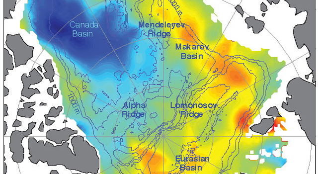
Increasing freshwater on the U.S. and Canadian side of the Arctic from 2005 to 2008 is balanced by decreasing freshwater on the Russian side, so that on average the Arctic did not have more freshwater. Here blue represents maximum freshwater increases and the yellows and oranges represent maximum freshwater decreases. Credit: University of Washington

Increasing freshwater on the U.S. and Canadian side of the Arctic from 2005 to 2008 is balanced by decreasing freshwater on the Russian side, so that on average the Arctic did not have more freshwater. Here blue represents maximum freshwater increases and the yellows and oranges represent maximum freshwater decreases. Credit: University of Washington

01.04.12
By Alan Buis,
Jet Propulsion Laboratory

A new NASA and University of Washington study allays concerns that melting Arctic sea ice could be increasing the amount of freshwater in the Arctic enough to have an impact on the global "ocean conveyor belt" that redistributes heat around our planet.
Lead author and oceanographer Jamie Morison of the University of Washington's Applied Physics Laboratory in Seattle, and his team, detected a previously unknown redistribution of freshwater during the past decade from the Eurasian half of the Arctic Ocean to the Canadian half. Yet despite the redistribution, they found no change in the net amount of freshwater in the Arctic that might signal a change in the conveyor belt.
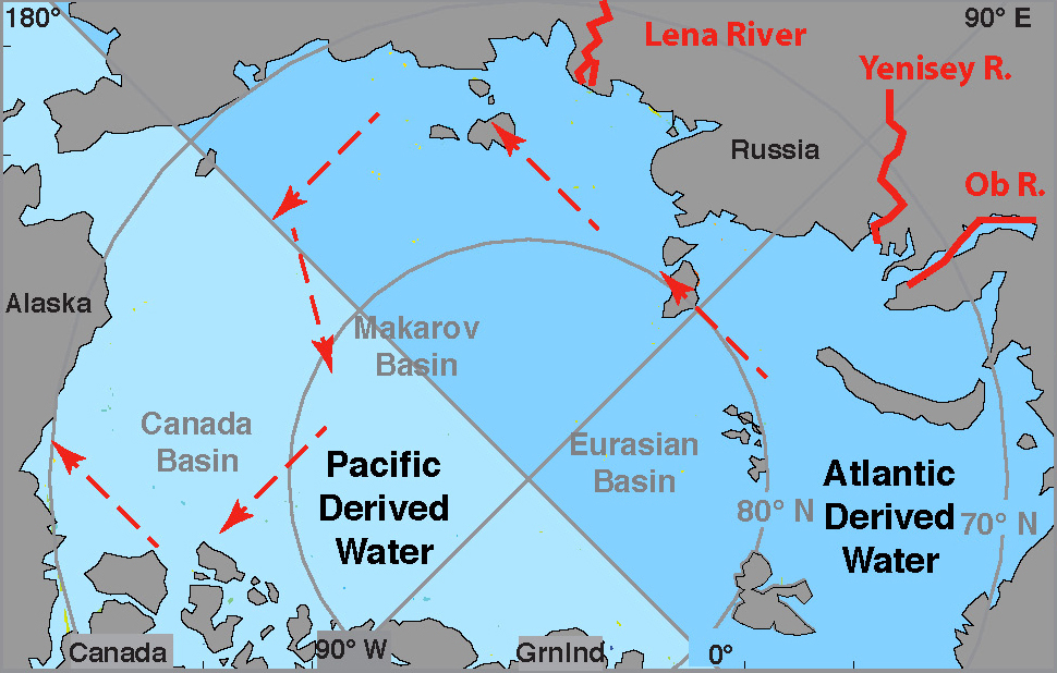
The team attributes the redistribution to an eastward shift in the path of Russian runoff through the Arctic Ocean, which is tied to an increase in the strength of the Northern Hemisphere's west-to-east atmospheric circulation, known as the Arctic Oscillation. The resulting counterclockwise winds changed the direction of ocean circulation, diverting upper-ocean freshwater from Russian rivers away from the Arctic's Eurasian Basin, between Russia and Greenland, to the Beaufort Sea in the Canada Basin bordered by the United States and Canada. The stronger Arctic Oscillation is associated with two decades of reduced atmospheric pressure over the Russian side of the Arctic. Results of the NASA- and National Science Foundation-funded study are published Jan. 5 in the journal Nature.
Between 2003 and 2008, the resulting redistribution of freshwater was equivalent to adding 10 feet (3 meters) of freshwater over the central Beaufort Sea.
The freshwater changes were seen between 2005 and 2008 by combining ocean bottom pressure, or mass, data from NASA's Gravity Recovery and Climate Experiment satellites with ocean height data from NASA's ICESat satellite. By calculating the difference between the two sets of measurements, the team was able to map changes in freshwater content over the entire Arctic Ocean, including regions where direct water sample measurements are not available.
Red arrows show the new path of Russian river water into the Canada Basin. The previous freshwater pathway - across the Eurasian Basin toward Greenland and the Atlantic - was altered by atmospheric conditions created by the Arctic Oscillation. Credit: University of Washington
"Knowing the pathways of freshwater is important to understanding global climate because freshwater protects sea ice by helping create a strongly stratified cold layer between the ice and warmer, saltier water below that comes into the Arctic from the Atlantic Ocean," said Morison. "The reduction in freshwater entering the Eurasian Basin resulting from the Arctic Oscillation change could contribute to sea ice declines in that part of the Arctic."
"Changes in the volume and extent of Arctic sea ice in recent years have focused attention on melting ice," said co-author and senior research scientist Ron Kwok of NASA's Jet Propulsion Laboratory, Pasadena, Calif., which manages Grace for NASA. "The Grace and ICESat data allow us to now examine the impacts of widespread changes in ocean circulation."
An instrument about to be dropped through an opening in the ice to the seafloor will record ocean bottom pressure to compare with similar data recorded by NASA's GRACE satellites. Data from GRACE, ICESat and actual water samples led to the discovery of a new pathway of freshwater in the Arctic. Credit: C. Peralta-Ferriz/UW Applied Physics Laboratory
Kwok said on whole, Arctic Ocean salinity is similar to what it was in the past, but the Eurasian Basin has become more saline, and the Canada Basin has freshened. In the Beaufort Sea, the water is the freshest it's been in 50 years of record keeping, with only a tiny fraction of that freshwater originating from melting ice and the vast majority coming from Russian river water.
The Beaufort Sea stores more freshwater when an atmospheric pressure system called the Beaufort High strengthens, driving a counterclockwise wind pattern. Consequently, it has been argued that the primary cause of freshening is a strengthening of the Beaufort High, but salinity began to decline early in the 1990s, when the Beaufort High relaxed and the counterclockwise Arctic Oscillation pattern increased.
"We discovered a pathway that allows Russian river runoff to feed the Beaufort gyre," Kwok said. "The Beaufort High is important, but so are the hemispheric-scale effects of the Arctic Oscillation."
"To better understand climate-related changes in sea ice and the Arctic overall, climate models need to more accurately represent the Arctic Oscillation's low pressure and counterclockwise circulation on the Russian side of the Arctic Ocean," Morison added.

NASA finds 2011 ninth-warmest year on record


While average global temperature will still fluctuate from year to year, scientists focus on the decadal trend. Nine of the 10 warmest years since 1880 have occurred since the year 2000, as the Earth has experienced sustained higher temperatures than in any decade during the 20th century. As greenhouse gas emissions and atmospheric carbon dioxide levels continue to rise, scientists expect the long-term temperature increase to continue as well. (Data source: NASA Goddard Institute for Space Studies. Credit: NASA Earth Observatory, Robert Simmon)


The global average surface temperature in 2011 was the ninth warmest since 1880, according to NASA scientists. The finding continues a trend in which nine of the 10 warmest years in the modern meteorological record have occurred since the year 2000.

NASA's Goddard Institute for Space Studies (GISS) in New York, which monitors global surface temperatures on an ongoing basis, released an updated analysis that shows temperatures around the globe in 2011 compared to the average global temperature from the mid-20th century. The comparison shows how Earth continues to experience warmer temperatures than several decades ago. The average temperature around the globe in 2011 was 0.92 degrees F (0.51 C) warmer than the mid-20th century baseline.


Global temperatures have warmed significantly since 1880, the beginning of what scientists call the "modern record." At this time, the coverage provided by weather stations allowed for essentially global temperature data. As greenhouse gas emissions from energy production, industry and vehicles have increased, temperatures have climbed, most notably since the late 1970s. In this animation of temperature data from 1880-2011, reds indicate temperatures higher than the average during a baseline period of 1951-1980, while blues indicate lower temperatures than the baseline average. (Data source: NASA Goddard Institute for Space Studies. Visualization credit: NASA Goddard Space Flight Center Scientific Visualization Studio)

"We know the planet is absorbing more energy than it is emitting," said GISS Director James E. Hansen. "So we are continuing to see a trend toward higher temperatures. Even with the cooling effects of a strong La Niña influence and low solar activity for the past several years, 2011 was one of the 10 warmest years on record."

The difference between 2011 and the warmest year in the GISS record (2010) is 0.22 degrees F (0.12 C). This underscores the emphasis scientists put on the long-term trend of global temperature rise. Because of the large natural variability of climate, scientists do not expect temperatures to rise consistently year after year. However, they do expect a continuing temperature rise over decades.

The first 11 years of the 21st century experienced notably higher temperatures compared to the middle and late 20th century, Hansen said. The only year from the 20th century in the top 10 warmest years on record is 1998.

Higher temperatures today are largely sustained by increased atmospheric concentrations of greenhouse gases, especially carbon dioxide. These gases absorb infrared radiation emitted by Earth and release that energy into the atmosphere rather than allowing it to escape to space. As their atmospheric concentration has increased, the amount of energy "trapped" by these gases has led to higher temperatures.

The carbon dioxide level in the atmosphere was about 285 parts per million in 1880, when the GISS global temperature record begins. By 1960, the average concentration had risen to about 315 parts per million. Today it exceeds 390 parts per million and continues to rise at an accelerating pace.

The temperature analysis produced at GISS is compiled from weather data from more than 1,000 meteorological stations around the world, satellite observations of sea surface temperature and Antarctic research station measurements. A publicly available computer program is used to calculate the difference between surface temperature in a given month and the average temperature for the same place during 1951 to 1980. This three-decade period functions as a baseline for the analysis.

The resulting temperature record is very close to analyses by the Met Office Hadley Centre in the United Kingdom and the National Oceanic and Atmospheric Administration's National Climatic Data Center in Asheville, N.C.

Hansen said he expects record-breaking global average temperature in the next two to three years because solar activity is on the upswing and the next El Niño will increase tropical Pacific temperatures. The warmest years on record were 2005 and 2010, in a virtual tie.

"It's always dangerous to make predictions about El Niño, but it's safe to say we'll see one in the next three years," Hansen said. "It won't take a very strong El Niño to push temperatures above 2010."

Wednesday, 7 December 2011

Satellite confirms decline in pollution from coal power plants

12.07.11
Adam Voiland and Rani Gran,
NASA's Goddard Space Flight Center

A team of scientists have used the Ozone Monitoring Instrument (OMI) on NASA's Aura satellite to confirm major reductions in the levels of a key air pollutant generated by coal power plants in the eastern United States. The pollutant, sulfur dioxide, contributes to the formation of acid rain and can cause serious health problems.

The scientists, led by an Environment Canada researcher, have shown that sulfur dioxide levels in the vicinity of major coal power plants have fallen by nearly half since 2005. The new findings, the first satellite observations of this type, confirm ground-based measurements of declining sulfur dioxide levels and demonstrate that scientists can potentially measure levels of harmful emissions throughout the world, even in places where ground monitoring is not extensive or does not exist. About two-thirds of sulfur dioxide pollution in American air comes from coal power plants. Geophysical Research Letterspublished details of the new research this month.


These maps show average sulfur dioxide levels measured by the Aura satellite for the periods 2005-2007 (top) and 2008-2010 (bottom) over a portion of the eastern United States. The black dots represent the locations of many of the nation's top sulfur dioxide emissions sources. Larger dots indicate greater emissions. (Credit: NASA's Earth Observatory)


The scientists attribute the decline in sulfur dioxide to the Clean Air Interstate Rule, a rule passed by the U.S. Environmental Protection Agency in 2005 that called for deep cuts in sulfur dioxide emissions. In response to that rule, many power plants in the United States have installed desulfurization devices and taken other steps that limit the release of sulfur dioxide. The rule put a cap on emissions, but left it up to power companies to determine how to reduce emissions and allowed companies to trade pollution credits.

While scientists have used the Ozone Monitoring Instrument to observe sulfur dioxide levels within large plumes of volcanic ash and over heavily polluted parts of China in the past, this is the first time they have observed such subtle details over the United States, a region of the world that in comparison to fast-growing parts of Asia now has relatively modest sulfur dioxide emissions. Just a few decades ago, sulfur dioxide pollution was quite severe in the United States. Levels of the pollutant have dropped by about 75 percent since the 1980s due largely to the passage of the Clean Air Act.

Vitali Fioletov, a scientist based in Toronto at Environment Canada, and his colleagues developed a new mathematical approach that made the improved measurements a reality. The approach centers on averaging measurements within a 30 miles radius (50 km) of a sulfur dioxide source over several years. "Vitali has developed an extremely powerful technique that makes it possible to detect emissions even when levels of sulfur dioxide are about four times lower than what we could detect previously," said Nickolay Krotkov, a researcher based at NASA’s Goddard Space Flight Center in Greenbelt, Md., and a coauthor of the new paper.

The technique allowed Fioletov and his colleagues to pinpoint the sulfur dioxide signals from the 40 largest sulfur dioxide sources in the United States -- generally coal power plants that emit more than 70 kilotons of sulfur dioxide per year. The scientists observed major declines in sulfur dioxide emissions from power plants in Alabama, Georgia, Indiana, Kentucky, North Carolina, Ohio, Pennsylvania and West Virginia by comparing levels of the pollutant for an average of the period 2005 to 2007 with another average from 2008 to 2010.

What we’re seeing in these satellite observations represents a major environmental accomplishment," said Bryan Bloomer, an Environmental Protection Agency scientist familiar with the new satellite observations. "This is a huge success story for the EPA and the Clean Air Interstate Rule," he said.

The researchers focused their analysis on the United States to take advantage of the presence of a robust network of ground-based instruments that monitor sulfur dioxide emissions inside power plant smokestacks. The ground-based instruments have logged a 46 percent decline in sulfur dioxide levels since 2005 -- a finding consistent with the 40 percent reduction observed by OMI.


Smokestacks from a coal power plant in Maryland jut into a hazy skyline. Credit: Jeff Stehr, University of Maryland


"Now that we’ve confirmed that the technique works, the next step is to use it for other parts of the world that don’t have ground-based sensors," said Krotkov. "The real beauty of using satellites is that we can apply the same technique to the entire globe in a consistent way." In addition, the team plans to use a similar technique to monitor other important pollutants that coal power plants release, such as nitrogen dioxide, a precursor to ozone.
OMI, a Dutch and Finnish built instrument, was launched in 2004, as one of four instruments on the NASA Aura satellite, and can measure sulfur dioxide more accurately than any satellite instrument flown to date. Though OMI remains in very good condition and scientists expect it to continue producing high-quality data for many years, the researchers also hope to use data from an upcoming Dutch-built OMI follow-on instrument called TROPOMI that is expected to launch on a European Space Agency satellite in 2014.

Artist's concept of the Aura spacecraft. Credit: NASA

On July 6, 2011, the U.S. Environmental Protection Agency (EPA) finalized the Cross-State Air Pollution Rule (CSAPR), requiring 27 states to significantly reduce power plant emissions that contribute to ozone and fine particle pollution in other states. This rule replaces EPA's 2005 Clean Air Interstate Rule (CAIR). A December 2008 court decision kept the requirements of CAIR in place temporarily but directed EPA to issue a new rule to implement Clean Air Act requirements concerning the transport of air pollution across state boundaries. This action responds to the court's concerns.

Thanks NASA

Share

Twitter Delicious Facebook Digg Stumbleupon Favorites More